
Truitjieskraal Rock Art
A short interpretive loop through standout sandstone formations with information boards and San rock art viewing areas. The walking is easy — most of the time goes into reading, viewing, and taking photos (respectfully).
Quick facts
Truitjieskraal is best treated as a short interpretive loop where you move slowly and stop often. Different sources list different loop distances, so the most honest summary is a ~1.5–3 km loop, with a typical visit of ~45–90 minutes depending on how much time you spend viewing rock art and exploring formations.
Overview
What makes it special
- Some of the most striking sandstone formations in the Matjiesrivier reserve system.
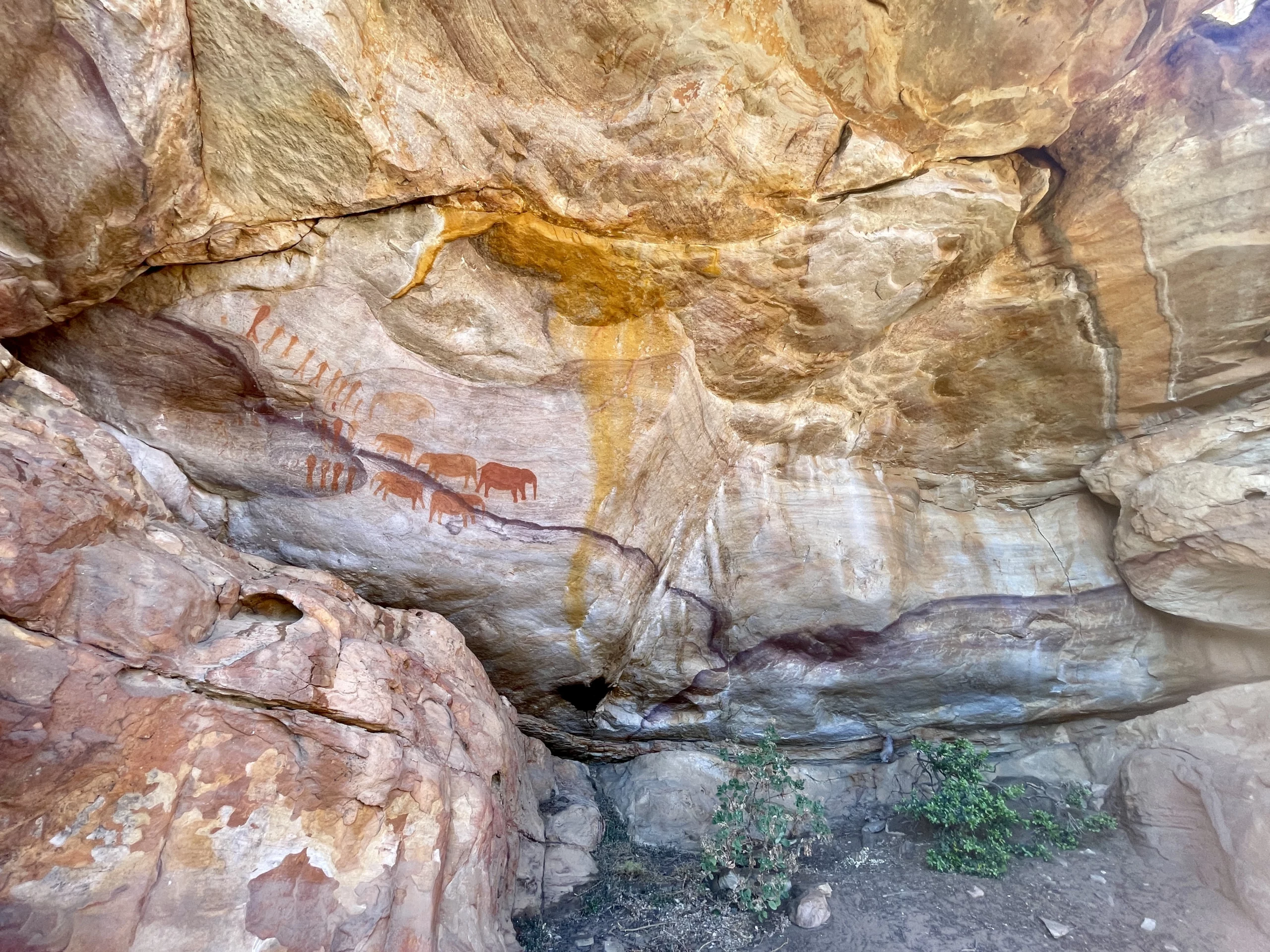
- San rock art viewing areas (including famous elephant depictions referenced in reserve info).
- Information boards that add cultural + environmental context while you walk.
Who it suits
- Everyone — it’s an easy walk rather than a strenuous hike.
- Visitors who want a meaningful cultural stop without a full-day mountain route.
- Photographers and families (with supervision near rock edges).
What “easy” means here
- Short walking distance on a marked route.
- Most “effort” comes from stopping and exploring rocks (optional).
- Heat and sun exposure still apply — carry water.
Route outline
Typical flow (interpretive loop)
- Start: park at the signed Truitjieskraal access/parking area (confirm at entry/office).
- Interpretive loop: follow the marked route through formations and information boards.
- Rock art stops: viewing areas are part of the experience — slow down and keep distance.
- Return: loop completes back at the parking area.
Why distance/time differs online
- Some references describe a shorter “interpretive” loop; others map a longer loop track.
- GPS recordings differ depending on wandering around formations (very common here).
- Time varies mainly by how long you spend reading boards and viewing rock art.
Rock art etiquette
What you’ll see (high level)
The reserve info describes rock art in this area as depicting groups of people and a herd of elephants. These sites are extremely sensitive — viewing is allowed, but contact damages the art.
- Look and photograph responsibly (follow any on-site signage about photography).
- Stay on the marked viewing areas and pathways.
Non-negotiables
- No touching (skin oils degrade pigment).
- No graffiti on any rock surfaces.
- No climbing near panels or leaning on painted areas.
Permits & access
Permit required
Matjiesrivier is controlled access: entry is with permit only, and the Matjiesrivier day visitor info sheet notes that permits are required for day trails (including Stadsaal and Truitjieskraal).
- Permits can be obtained via tourism offices in the Cederberg Conservancy or at listed CapeNature offices during office hours.
- Confirm the current permit point, gate times, and road conditions on the day.
Where it is
- Inside Matjiesrivier Nature Reserve (CapeNature).
- The reserve info also notes long gravel-road access and provides guidance that Stadsaal is a few km into the reserve, while Truitjieskraal turn-off is further along.
- Plan for slower driving if you’re not used to gravel roads.
Timing
Best time of day
- Morning or late afternoon for better rock texture and softer light.
- Midday can be harsh (heat + contrast).
How long to budget
- Quick loop: ~45 minutes is common for moving steadily.
- Typical visit: ~60–90 minutes with stops.
- Photo-heavy exploring: 2+ hours is normal.
Season notes
- Cooler months are more comfortable for walking in exposed terrain.
- After rain, sandstone can be slippery — especially if you climb around formations.
What to bring
Essentials
- Drinking water (reserve info notes no drinking water at Truitjieskraal)
- Hat + sunblock
- Closed shoes with grip
- Phone/camera (plus power bank if you’re taking lots of photos)
Nice-to-haves
- Light wind layer
- Small snack (you’ll likely linger)
- Basic first aid (scrapes happen when people climb rocks)
Safety
Critical notes from reserve info
- No cell phone reception (last reception point noted at Algeria).
- No drinking water available at Truitjieskraal.
- No pets and no graffiti (strict rules).
On-site common sense
- Supervise children near rock edges and climbing spots.
- Move carefully on smooth rock, especially if sandy or wet.
- If it’s brutally hot or windy, shorten the visit and stay conservative.
FAQ
Is it a hike or a walk?
It’s an easy interpretive walk. The route is short; the experience is in the stops (boards, art, formations).
How long is the loop?
Different sources list different loop lengths, typically between about 1.5 km and ~2.6–3 km. Your distance will also increase if you wander around the formations.
Do I need a permit?
Yes — Matjiesrivier is entry-with-permit, and permits are required for day trails including Truitjieskraal.
Can I combine it with Stadsaal?
Yes — Stadsaal Caves and Truitjieskraal are frequently visited together in Matjiesrivier on the same day.
Accuracy policy: This page uses CapeNature’s Matjiesrivier reserve guidance for permits/rules and uses a range for trail distance/time because published loop lengths differ between sources. Confirm current access/permit rules and road conditions at your entry/permit point before arrival.